Wednesday, November 28, 2018

Best & Worst Places to be in B.C. in an Earthquake

Dr. Clague is Minimalist.  What I find so objectionable about Dr. Clague demeanor, dialogue, presentations and reports is that he downplays the risks we are facing.  That only leads to people being even less prepared.  Obviously, he has never personally experienced a BIG earthquake of tsunami and doesn't know what he is talking about ~ Stan G. Webb -

New Cascadia Dawn©


Citytv
Published on Jan 15, 2015

Senate Ways & Means Cascadia Subduction Zone Presentation Work Session, ...


https://youtu.be/gjbBx6tMfR0 [56:55 minutes]

If we keep listening to Dr John Clague and 72 Hours Survival & First Aid, many more of us will die. Dr. John Clague was writing reports, and charging the City and District of North Vancouver, stating that the tsunami height would be one to two metres here. He should tell everyone that he didn't know anything at all, withdraw his 'expert' reports and give everyone their money back. I bought and tested things from 72 Hours the 'merchants of fear' three years ago. They sell nothing but cheap Chinese shit; prone to failure on testing, most every time. https://cascadiamegaquake.blogspot.com/

If you want to survive, HOW ARE WE GOING TO PAY FOR IT ALL ? - Senate Ways & Means Cascadia Subduction Zone Presentation Work Session, ...

SUMMARY: If you want to survive, recognize that at first you will be all alone and uninsured. We will need to take care of the after-effects of all of this ourselves.
STILL IT GETS PUSHED TO THE END OF A VERY BUSY AGENDA. This requires that we expect more from our leadership and that we elect serious, sober and somber people into office; NOT bratty, cute, entitled STUPID children. One member of this committee WALKED OUT, even before this presentation had been concluded.
Washington State Senate Ways & Means Cascadia Subduction Zone Presentation Work Session, Feb 12 2017

Monday, November 26, 2018

Cascadia Working Group©

Thank you for helping me do this.

This is the website for:
Cascadia Working Group© [https://cascadiaworkinggroup.blogspot.com/] so that hyperlinks work for all of us.
If you decide to help with this it will be easiest for you if you just email me once; and I'll get back to you; then can just click on hyperlinks. stanwebb@gmail.com Facebook and Yahoo are NOT to be used in any way. I've experienced ID theft, personal information stolen and used.
For the next two months I'll be head down, concentrating on this. My deadline, I hope, is 9:00PM PST, Saturday, January 26, 2019, the 319h anniversary of the last Cascadia Megaquake which struck the west coast North America at 9:00PM on Tuesday, January 26, 1700 (21:00) local Pacific Standard Time. If we can help save one life, it'll be worth it.
I'll try to keep it on the down low until I have finished polished written material and have presentations ready. I will be laser focused on preparing material to help educate people ~ so that they can help prepare their grandchildren for this.
At 9:00PM PST, Saturday, January 26, 2019. I hope by then, that we will all be on the same page, and all have the chance to go out and discuss this.
I've been using YouTube, Blogger and other free Google products. I have used Wikipedia as a hyperlinked reference point since 1997; and edited it since 2003. In November, 2016 I fired Marisa Meyer and Yahoo after she leaked information on 500 million of us users. Facebook and Google are now also under scrutiny. People are too loose with their private information. GPS on my cellphone or camera, I don't think so.
In November, 2016, I went to Gimli, New Iceland, Manitoba to go to The New Iceland Heritage Museum. [Gimli Webcam refreshes ever few minutes.]. I highly recommend that visit. Gimli is on Central Time, two hours earlier than Pacific Standard Time. I met with some of the descendants of families of the seismic survivors who fled an eruption of the Icelandic volcano Askja in 1875 (1/3 of the entire population of Iceland). Icelandic Canadians are Canadian citizens of Icelandic ancestry and some Iceland-born people who reside in Canada. Canada has the largest ethnic Icelandic population outside Iceland, with about 101,795 people of Icelandic descent as of the Canada 2016 Census. New Iceland – Wikipedia https://en.wikipedia.org/wiki/New_Iceland.
In September, 2017, I dropped in on three members (the day shift) at the Japanese Seismic Team's Monitoring Station of Cascadia's Fault. in Tofino. At least the Japanese are taking this very, very seriously. Since I know what is going to happen soon, that particular trip very poignant; scary, even.
Some details: The last Cascadia Megaquake struck the west coast of North America at 9:00PM on Tuesday, January 26, 1700 (21:00) local Pacific Standard Time (5:00AM next day, Coordinated Universal Time (UTC) ). The next day the Megatsunami arrived in Japan at midnight, Thursday, Japan Standard Time (JST). The Cascadia Megatsunami 'wave train' was in a series of seven long-period waves, 20 – 30 minutes apart later. A long-period wave is one where the crest of each successive wave can be 300 ~ 800 kilometres, and more apart. Often the third in the series is the largest and most destructive. These types of 'waves' are not really what I would call a wave, at all; a 'flood' would be more descriptive.
Geologists have also determined the Pacific Northwest is not prepared for such a colossal quake. The tsunami produced could reach heights of 80 to 100 feet (24 to 30 m). A 2004 study revealed the potential for relative mean sea level rise (caused by subsidence) along the Cascadia subduction zone. My 'reverse engineering' and physics show it higher , at Anacla the tsunami would have been twelve stories, over 37 metres (120 feet) high.''.

All along our west coast First Nations have stories and talk about it, referring to it as a flood. Floods come in low, and raise from below. In a Cascadia Megaquake the source of the Cascadia Megatsunami is referred to as the Cascadia fault, about 80 kilometres off the coast, down 2,000 metres or so below the surface of the Pacific Ocean. When that Cascadia Fault ruptures it will push up an entire column of water from the torn ocean bottom to the top of the ocean surface, from north of Vancouver Island, all along 1.000-1,200 kilometres south to northern California. In Japan, 8,000 kilometres away, traveling at the speed of a Boeing 747 Jumbo Jet (700 kilometre/hour), the last Cascadia Megatsunami arrived, after having crossed the International Date Line, through seven time zones at around midnight, January 27, 1700.
Scientific American ~ Thunderbird and the Orphan Tsunami: Cascadia 1700 By Dana Hunter on January 26, 2016 It was the 316th (in 2016) anniversary of the 1700 Cascadia megathrust earthquake and tsunami!
It invaded towns along the coast, inexorable. The worst damage happened in the north. In the Miyako Bay area, where the tsunami probably reached a height of five meters, the floodwaters ripped apart or washed out thirteen houses in the town of Kuwagasaki as villagers fled to high ground. Twenty-one more houses burned in the ensuing fires.* Happily, everybody lived, and they would be able to rebuild when the fires were out and the waters receded.

Seven kilometers away in Tsugaruishi, houses along the shore were swept away. Floodwaters proceeded into town a kilometer inland from the bay, and the tsunami barreled up the Tsugaruishi River all the way to Kubota Crossing. Villagers panicked when it nearly reached Inarinoshita, just below Inari Shrine. But they and their shrine survived the night. … (more
US NOAA – National Oceanic and Atmospheric Administration The full report about Japan's Orphan Tsunami of 1700 can be found here.
For a YouTube version of this animation, please see: https://youtu.be/4W2iUl0VB8c
The Last Cascadia Great Earthquake and Tsunami;
313 Years and Ticking
Thousands of coastal residents settled in for the night on January 26th 1700 when the ground began to shake. For most, the first signs were subtle, dogs barked nervously as the primary or “P” wave vibrations passed by. The earthquake became unmistakable when the “S” (secondary or shear) waves arrived at village after village traveling at about 6 kilometers a second as the entire Cascadia Subduction Zone ruptured. The 1000 km long fault rupture propagated from its origin at about 3 km a second, generating fresh seismic waves as the fault continued to unzip and slip. Assuming the rupture began in Northern California, it likely took over 5 minutes break the entire fault to northern Vancouver Island.
The earthquake that released about 1500 times the seismic energy than the 2001 M 6.8 Nisqually Earthquake, and can be seen as a connected series of large earthquakes at least one of which produced very low frequency waves with 10s of meters of displacement, and a dramatic popping up of the sea floor that lifted a great column of water;
The Last Cascadia Great Earthquake and Tsunami; 313 Years and Ticking
That uplifted column of water then collapsed producing a series of tsunami waves that would batter the coastline through the night and cross the Pacific basin. Though all people west of the Cascades were disrupted by the shaking and some injured by falling logs and possessions, it was the water that likely claimed the hundreds of lives lost that night when villages were overtopped by tsunami generated floods.
The 1980s was a decade of discovery of evidence for great earthquakes in the Cascadia Region. Tom Heaton and Hiroo Kanamori published a paper asserting the Cascadia Subduction Zone was indeed actively deforming and is likely to produce great earthquakes. Brian Atwater’s 1987 paper in Science provided the necessary “ground truthing” of these theories describing repeated abrupt co-seismic land level changes along our coast and evidence of tsunami inundation following periodic great earthquakes. Atwater with many scientific colleagues continued to work over decades to tease out the details of magnitude, shaking levels, tsunami hazards, and reoccurrence rate of great Cascadia earthquakes. This work also involved the study of earthquakes in other subduction zones around the world and provided the precise date and even the hour of the 1700 earthquake derived from the arrival time of the Cascadia Tsunami in Japan. We now know a ~magnitude 9 earthquake struck our region on January 26, 1700 at ~9:00 PM. We also know the fault is reloaded with strain and capable of producing another great earthquake today though it is probable that we have many decades with which to prepare for this inevitable earthquake.
Scientists have had many examples of these subduction zone earthquakes to study over the past 10 years as hundreds of thousands of people have died in great earthquakes and the tsunami waves they produced. The largest of these, the Mw 9.1 2004 Sumatra-Andaman Earthquake and Indian Ocean Tsunami killed between 230 and 300 thousand people in Indonesia and at least 15 other nations. A dozen other great earthquakes occurred over the past 10 years including the 2010 M 8.8 Maule, Chile Earthquake and the Great East Japan Earthquake of March 11, 2011 in which over 15,000 Japanese died, over 92% from drowning during the tsunami flooding.
The Cascadia Subduction Zone has remained locked, loaded, and quiet through all this tumult. It does not even produce the small earthquakes so prevalent in other subduction zones around the world. The Cascadia Subduction Zone behaves differently than all other subduction zones on the planet. Scientists also see significant variation in behavior from one subduction zone to the next so it is hard to know what lessons should we learn from these earthquakes to lower our losses when our fault breaks loose again. Despite the natural variations between faults and earthquake effects, some clear conclusions can be made.
Emergency response will be slow and households, particularly in rural and coastal areas, need to be self sufficient for food, water, and medicine for weeks, not just days. It is not realistic to think that the millions of people impacted by this regional event will receive assistance within 72 hours of the earthquake. Unfortunately, only a minority of households have the old 3 day minimum of disaster supplies on hand. We must set aside more.
Kindest personal regards

Friday, November 23, 2018


I'll put this up on a website Cascadia Working Group© [https://cascadiaworkinggroup.blogspot.com/] so that hyperlinks work for all of us.Image result for image cascadia fault


If you decide to help with this it will be easiest for you if you just email me once: stanwebb@gmail.com and I'll get back to you; then you can just click on hyperlinks.  Facebook and Yahoo are NOT to be used in any way. I've experienced ID theft, personal information stolen and used.  In November, 2016 I fired Marisa Meyer and Yahoo after she leaked information on 500 million of us users. Facebook and Google are now also under scrutiny. People are too loose with their private information.  GPS on my cellphone or camera, I don't think so.
For the next two months I'll be head down, concentrating on this. My deadline, I hope, is 9:00PM PST, Saturday, January 26, 2019, the 319h anniversary of the last Cascadia Megaquake which struck the west coast of North America at 9:00PM on Tuesday, January 26, 1700 (21:00) local Pacific Standard Time. If we can help save one life, it'll be worth it.
I would like this to be kept quiet until we have finished polished written material and have presentations ready. I will be laser focused on preparing material to help educate people ~ so that they can help prepare their grandchildren for this.
At 9:00PM PST, Saturday, January 26, 2019. I hope by then, that we will all be on the same page, and all have the chance to go out and discuss this.
I've been using YouTube, Blogger and other free Google products. I have used Wikipedia as a hyperlinked reference point since 1997; and started editing it in 2003.
In November, 2017, I went to Gimli, New Iceland, Manitoba to go to The New Iceland Heritage Museum. [Gimli Webcam refreshes ever few minutes.]. I highly recommend that visit. Gimli is on Central Time, two hours earlier than Pacific Standard Time. I met with some of the descendants of families of the seismic survivors who fled an eruption of the Icelandic volcano Askja in 1875 (1/3 of the entire population of Iceland). Icelandic Canadians are Canadian citizens of Icelandic ancestry and some Iceland-born people who reside in Canada. Canada has the largest ethnic Icelandic population outside Iceland, with about 101,795 people of Icelandic descent as of the Canada 2016 Census. New Iceland – Wikipedia https://en.wikipedia.org/wiki/New_Iceland.

Image result for image cascadia fault
Some details: The last Cascadia Megaquake struck the west coast of North America at 9:00PM on Tuesday, January 26, 1700 (21:00) local Pacific Standard Time. The next day the Megatsunami arrived in Japan at midnight, Wednesday  Japan Standard Time (JST).  (5:00AM next day, Coordinated Universal Time (UTC) The Cascadia Megatsunami 'wave train' was in a series of seven long-period waves, 20 – 30 minutes apart, later. A long-period wave is one where the crest of each successive wave can be 300 ~ 800 kilometres, and more, apart. Often the third in the series is the largest and most destructive. These types of 'waves' are not really what I would call a waves, at all; a 'flood' would be more descriptive.
Geologists have determined the US Pacific Northwest is not prepared for such a colossal quake. Canada is worse.  Those geologists estimate the  tsunami produced could reach heights of 24 to 30 m (80 to 100 feet).  A 2004 study revealed the potential for relative mean sea level rise (caused by subsidence) along the Cascadia subduction zone. My 'reverse engineering' and physics show it higher.  At Anacla the tsunami would have been twelve stories, over 37 metres (120 feet) high.''.
All along our west coast First Nations have stories and talk about it, referring to it as a flood. Floods come in low, and raise from below. In a Cascadia Megaquake the source of the Cascadia Megatsunami is referred to as the Cascadia 
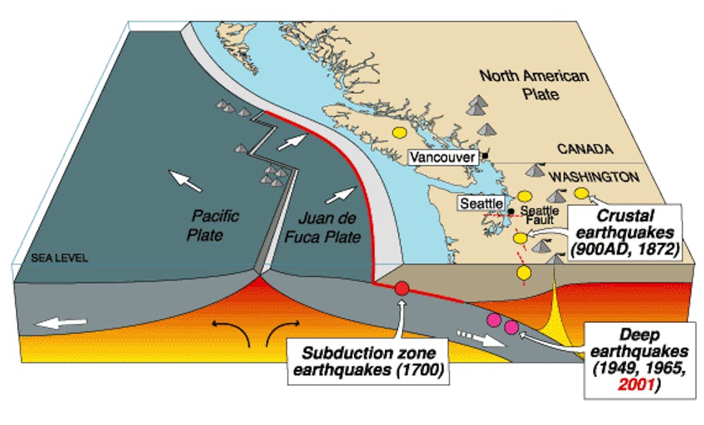
fault, the point at which the Explorer, Juan de Fuca and Gorda Tectonic Plates start 'subducting' (or sinking) beneath the overriding North American Tectonic Plate.  That starts happening about 80 kilometres off the coast, down 2,000 metres or so below the surface of the Pacific Ocean. When the Cascadia Fault ruptures it will push up an entire column of water from the torn ocean bottom to the top of the ocean surface, from north of Vancouver Island, all along 1.000-1,200 kilometres south to northern California. In Japan, 8,000 kilometres away, traveling at the speed of a Boeing 747 Jumbo Jet (700 kilometre/hour), the last Cascadia Megatsunami arrived, after having crossed the International Date Line, through seven time zones at around midnight, January 27, 1700.

Scientific American ~ Thunderbird and the Orphan Tsunami: Cascadia 1700 By Dana Hunter on January 26, 2016 it was the 316th (in 2016) anniversary of the 1700 Cascadia megathrust earthquake and tsunami!
It invaded towns along the coast, inexorable. The worst damage happened in the north. In the Miyako Bay area, where the tsunami probably reached a height of five meters, the floodwaters ripped apart or washed out thirteen houses in the town of Kuwagasaki as villagers fled to high ground. Twenty-one more houses burned in the ensuing fires.* Happily, everybody lived, and they would be able to rebuild when the fires were out and the waters receded.  (In other areas it was reported to be four stories, 12 metres).
Seven kilometers away in Tsugaruishi, houses along the shore were swept away. Floodwaters proceeded into town a kilometer inland from the bay, and the tsunami barreled up the Tsugaruishi River all the way to Kubota Crossing. Villagers panicked when it nearly reached Inarinoshita, just below Inari Shrine. But they and their shrine survived the night. … (more

US NOAA – National Oceanic and Atmospheric Administration The full report about Japan's Orphan Tsunami of 1700 can be found here.
For a YouTube version of this animation, please see: https://youtu.be/4W2iUl0VB8c
The Last Cascadia Great Earthquake and Tsunami;
313 Years and Ticking
Thousands of coastal residents settled in for the night on January 26th 1700 when the ground began to shake. For most, the first signs were subtle, dogs barked nervously as the primary or “P” wave vibrations passed by. The earthquake became unmistakable when the “S” (secondary or shear) waves arrived at village after village traveling at about 6 kilometers a second as the entire Cascadia Subduction Zone ruptured. The 1000 km long fault rupture propagated from its origin at about 3 km a second, generating fresh seismic waves as the fault continued to unzip and slip. Assuming the rupture began in Northern California, it likely took over 5 minutes break the entire fault to northern Vancouver Island.
The earthquake that released about 1500 times the seismic energy than the 2001 M 6.8 Nisqually Earthquake, and can be seen as a connected series of large earthquakes at least one of which produced very low frequency waves with 10s of meters of displacement, and a dramatic popping up of the sea floor that lifted a great column of water;
The Last Cascadia Great Earthquake and Tsunami; 313 Years and Ticking
That uplifted column of water then collapsed producing a series of tsunami waves that would batter the coastline through the night and cross the Pacific basin. Though all people west of the Cascades were disrupted by the shaking and some injured by falling logs and possessions, it was the water that likely claimed the hundreds of lives lost that night when villages were overtopped by tsunami generated floods.
The 1980s was a decade of discovery of evidence for great earthquakes in the Cascadia Region. Tom Heaton and Hiroo Kanamori published a paper asserting the Cascadia Subduction Zone was indeed actively deforming and is likely to produce great earthquakes. Brian Atwater’s 1987 paper in Science provided the necessary “ground truthing” of these theories describing repeated abrupt co-seismic land level changes along our coast and evidence of tsunami inundation following periodic great earthquakes. Atwater with many scientific colleagues continued to work over decades to tease out the details of magnitude, shaking levels, tsunami hazards, and reoccurrence rate of great Cascadia earthquakes. This work also involved the study of earthquakes in other subduction zones around the world and provided the precise date and even the hour of the 1700 earthquake derived from the arrival time of the Cascadia Tsunami in Japan. We now know a ~magnitude 9 earthquake struck our region on January 26, 1700 at ~9:00 PM. We also know the fault is reloaded with strain and capable of producing another great earthquake today though it is probable that we have many decades with which to prepare for this inevitable earthquake.
Scientists have had many examples of these subduction zone earthquakes to study over the past 10 years as hundreds of thousands of people have died in great earthquakes and the tsunami waves they produced. The largest of these, the Mw 9.1 2004 Sumatra-Andaman Earthquake and Indian Ocean Tsunami killed between 230 and 300 thousand people in Indonesia and at least 15 other nations. A dozen other great earthquakes occurred over the past 10 years including the 2010 M 8.8 Maule, Chile Earthquake and the Great East Japan Earthquake of March 11, 2011 in which over 15,000 Japanese died, over 92% from drowning during the tsunami flooding.
The Cascadia Subduction Zone has remained locked, loaded, and quiet through all this tumult. It does not even produce the small earthquakes so prevalent in other subduction zones around the world. The Cascadia Subduction Zone behaves differently than all other subduction zones on the planet. Scientists also see significant variation in behavior from one subduction zone to the next so it is hard to know what lessons should we learn from these earthquakes to lower our losses when our fault breaks loose again. Despite the natural variations between faults and earthquake effects, some clear conclusions can be made.
Emergency response will be slow and households, particularly in rural and coastal areas, need to be self sufficient for food, water, and medicine for weeks, not just days. It is not realistic to think that the millions of people impacted by this regional event will receive assistance within 72 hours of the earthquake. Unfortunately, only a minority of households have the old 3 day minimum of disaster supplies on hand. We must set aside more.

Wednesday, November 21, 2018

The Really Big One

This is getting really depressing; so from now on I'll concentrate upon how to help my family, friends, neighbours and myself survive.  Thank you for your help.
Cellphone Towers
Backup Generators
One Floor Above Me
   
This Is I Where
Live, On The
Top (16th) Floor
https://youtu.be/-EGqKhWc5wU   [51:45 minutes]

University of California Television (UCTV)
Published on Dec 7, 2015
(Visit: http://www.uctv.tv/)
Most people think that in the United States, the area around the San Andreas Fault poses the highest risk for a large earthquake. But the risk for a "great earthquake" and tsunami is highest in the Western Canada and the US Pacific Northwest.
Join seismologist Diego Melgar and learn about the risks, the geologic forces behind the potential for a truly massive Canada / U.S. earthquake, and efforts underway to build warning systems for the western U.S. Series: "Jeffrey B.  Graham Perspectives on Ocean Science Lecture Series" [12/2015] [Science] [Show ID: 29994]